UNDERMINING RIGHTS

Indigenous Lands and Mining in the Amazon

Partners:

Endnotes

  1. 1. Revenue, including foreign exchange, is generated from royalties, taxes, fees, fines, and other sources.
  2. 2. Commercial-scale mining has an employment multiplier effect from two to five, including indirect jobs that support mining, and induced jobs that are a result of direct and indirect employees spending money in the community (Walser 2002).
  3. 3. The comparative importance of mining and contribution to the world’s GDP during the last century shows an increase by a factor of 27 in ores and minerals production, and by a factor of eight in total materials extraction, while GDP rose 23-fold (Carvalho 2017).
  4. 4. Peru’s Fiscal Stabilization Fund was created in 1999 to give the government spending capacity in the face of emergencies (Salas et al. 2018).
  5. 5. Dredging involves the extraction of gold or other minerals from sand, gravel, and dirt on the bottom of streams, rivers, and other water bodies.
  6. 6. More than 1,000 murders have been recorded by Global Witness since 2010. UN Rapporteurs and regional human rights bodies, including the Inter-American Commission on Human Rights (IACHR), have also documented a distinct surge of instances of physical violence and criminalization of defenders, especially indigenous people. Moreover, the level of impunity is high for killings, with only 34 perpetrators charged, and just 10 convicted, of the 908 recorded killings between 2002 and 2013 (Global Witness 2014). Nearly all the known killings occurred in the context of large infrastructure developments, extractive industries, and other environmentally destructive projects.
  7. 7. In 2017, mining conflicts accounted for 36 killings (Global Witness 2018; Watts 2018).
  8. 8. The Amazon River basin is the portion of land drained by the Amazon River and its many tributaries.
  9. 9. For RAISG, the total area of the Amazon—7.8 million sq. km (calculated by GIS)—refers to the biogeographical boundary in Colombia and Venezuela; the Amazon basin boundary in Peru, Bolivia, Ecuador; the regional boundary (referred to as the Legal Amazon region) and the Amazon watershed in Brazil; and the entire countries of Guyana, French Guiana, and Suriname (RAISG 2019a).
  10. 10. The Amazon forest is Earth’s most biodiverse tract of tropical rainforest, with an estimated 16,000 tree species and 390 billion individual trees. At least 2.5 million insect species, 40,000 plant species, 2,200 fishes, 1,294 birds, 427 mammals, 428 amphibians, and 378 reptiles have been scientifically classified in the region. About 20 percent of the world’s bird and fish species are found in the Amazon (Da Silva et al. 2005).
  11. 11. Amazonian forest is estimated to have accumulated 0.62 ± 0.37 tonnes of carbon per hectare per year between 1975 and 1996 (Tian et al. 2000).
  12. 12. The Amazon River is about 640 km long (second in length to the Nile River) and the world’s largest in terms of discharge of water—about 6,591 cubic km of water per year.
  13. 13. Afro-descendants can be found in several Amazonian countries, including Brazil and Colombia. In Brazil, there are 2,962 quilombolas (Afro-Brazilian communities) with a total population of some 16 million people. Just 219 quilombolas have land titles, while 1,673 are pursuing the process of acquiring legal title. Titled quilombola territories include 767,596 ha (1.9 million acres); these settlements have a good record of protecting their forests (Branford and Torres 2018a). They claim, however, more than 20 million ha (Mongabay 2018).
  14. 14. Prior to 2000, forest loss was partly due to agrarian reforms by governments in each of the countries. In the 1990s and onwards governments began implementing environmental protection legislation as part of the general awareness raised about the impacts on environment (e.g., Rio Summit) and the need to take care of the environment for sustainability and for future generations.
  15. 15. From 27,772 sq. km/year to 4,571 sq. km/year.
  16. 16. The states of Pará, Mato Grosso, and Rondônia in Brazil accounted for nearly three quarters of deforestation—they are also major agricultural commodity producers (Weisse and Goldman 2019).
  17. 17. Almost half of the increase in deforestation in Colombia occurred in three regions–Meta, Guaviare, and Caquetá—with new hot spots of loss in previously untouched areas, including indigenous territories (Jong 2018; Weisse and Goldman 2019).
  18. 18. Together, the forests in South America, Africa, and Asia are now a net source of atmospheric carbon dioxide (Baccini et al. 2017).
  19. 19. Although market-oriented cattle production has expanded rapidly during the past decade, across much of the Amazon, a principal objective for cattle ranching is to establish land claims rather than produce beef or leather. In Brazil, 60 percent to 80 percent of cleared land ends up as pasture, most of which has low productivity, supporting less than one head per hectare (GFW 2020a; Barbosa 2019). In 2018, Brazil was the world’s top exporter of beef, accounting for around one-fifth of total exports, even though nearly 80 percent of production is for domestic consumption (GFW 2020a). Beginning in the early 1990s, industrial agricultural production, especially soybean farms, resulted in significant land use changes and loss of forest. In 2006, however, the Brazilian soybean industry established a moratorium on new forest clearing for soy.
  20. 20. Research shows that forests that have been selectively logged are eight times more likely to be settled and cleared by shifting cultivators than untouched forests because of access granted by logging roads (Butler 2019b).
  21. 21. RAISG identifies 327 oil or gas blocks available for bidding or under exploration across the basin (covering some 1.08 million sq. km).
  22. 22. As well as oil and natural gas extraction.
  23. 23. The remote southern Peruvian Amazon was made accessible by the completion of the Inter-Oceanic Highway connecting Peru and Brazil.
  24. 24. French Guiana, Suriname, and Venezuela were not included in this study largely because of the paucity of spatial data for GIS analysis on indigenous lands (Suriname), industrial concessions (Venezuela), and illegal mining sites (French Guiana and Suriname), as well as the difficulty of acquiring relevant national laws, regulations, and court rulings (French Guiana and Venezuela). More than 90 percent of the land in French Guiana and Suriname is forest, but these areas constitute only small portions of the Amazon (1 percent and 1.7 percent, respectively) and the Amazon population (0.5 percent and 1.1 percent, respectively). Venezuela includes 5.5 percent of the Amazon and 5 percent of the Amazon population.
  25. 25. Like minerals, the Amazon holds large reserves of oil and natural gas, and concessions for oil and gas exploration and extraction are proliferating across Amazon countries, especially in western Amazon. A vast extent of the Colombian, Peruvian, Ecuadorian, Bolivian, and Brazilian Amazon is under concession for oil and gas exploration and production. In 2012, more than 100 million ha of the Amazon were under concession for exploration and extraction of hydrocarbons, with Peru having the largest number of potential oil zones, covering 659,937 sq. km or 84 percent of the Peruvian Amazon (RAISG 2012). Colombia (193,414 sq. km–40 percent of the Colombian Amazon), Brazil (127,862 sq. km–21 percent), and Bolivia (73,215 sq. km–15 percent) follow (RAISG 2012). Moreover, the vast majority of planned drilling wells, production platforms, and pipeline routes overlap with indigenous territories, protected areas, and other critical/sensitive areas.
  26. 26. Established in 2007, RAISG is a network of eight civil society organizations from six Amazonian countries (Bolivia, Brazil, Colombia, Ecuador, Peru, and Venezuela) with extensive work experience with the Amazon and its indigenous peoples. The organizations include: Friends of Nature Foundation (Fundación Amigos de la Naturaleza, FAN, Bolivia), Institute for the Common Good (Instituto del Bien Común, IBC, Peru), Gaia Amazonas Foundation (Fundación Gaia Amazonas, FGA, Colombia), Ecuadorian Foundation for Ecological Studies (Fundación Ecuatoriana de Estudios Ecológicos, EcoCiencia, Ecuador), Provita (Provita, Venezuela), Wataniba (Wataniba, Venezuela), Amazon Institute of People and Environment (Instituto de Hombre y Medio Ambiente de la Amazonía, Imazon, Brazil), and Socio-environmental Institute (Instituto Socioambiental, ISA, Brazil). RAISG produces and disseminates knowledge, statistical data, and geospatial information on Amazonia.
  27. 27. There is no legal (industrial and ASM) or illegal mining data for French Guiana, and, for Suriname, there is no reliable indigenous land boundary data and no data on ASM and illegal mining.
  28. 28. Approximately 16,000 sq. km of mining concessions were classified as “no information,” which represents about 1 percent of the total area of mining concessions.
  29. 29. RAISG, using a definition of the Amazon larger than the biogeographic region, calculates that mining blocks cover 1.68 million sq. km of the Amazon. In Brazil, mining leases, concessions, and exploration permits cover 1.33 million sq. km—79 percent of all mining concessions in the Amazon basin (CITE).
  30. 30. The equation is: Percent forest loss inside indigenous lands 2000–2015 = (Area of forest loss 2000–2015 inside indigenous lands) / (Area of forest cover inside indigenous lands in 2000).
  31. 31. Sustainable Development Goal 16 is to “promote peaceful and inclusive societies for sustainable development, provide access to justice for all and build effective, accountable and inclusive institutions at all levels.” Target 16.1 is to “significantly reduce all forms of violence and related death rates everywhere” (UN 2019).
  32. 32. The Regional Agreement on Access to Information, Public Participation and Justice in Environmental Matters in Latin America and the Caribbean, which was adopted on March 4, 2018, in Escazú, Costa Rica. Also known as the Escazú Agreement, this binding instrument obligates governments to, among other matters, act to prevent attacks against defenders and address impunity. To date, of the nine Amazonian countries, Bolivia, Brazil, Ecuador, Guyana and Peru have signed the agreement, but only Guyana has ratified it. Suriname, Venezuela, and French Guiana have not signed the Escazú Agreement. It needs to be ratified by 11 states to enter into force, so, given that it has eight ratifications so far, it is not yet in force.
  33. 33. Venezuela has ratified ILO Convention 169, while Suriname and French Guiana have not.
  34. 34. Case of the Saramaka People v. Suriname 2007; case of the Sawhoyamaxa Indigenous Community v. Paraguay 2006 (Notess et al. 2018).
  35. 35. Simple translation of "La protección a la propiedad colectiva y al territorio ancestral se derivan de la relación espiritual y ancestral que existe con la tierra, por ser el lugar donde desarrollan sus actividades culturales, religiosas y económicas de acuerdo con sus tradiciones y costumbres, de modo que el concepto va más allá del título de propiedad, y en ese orden de ideas, es deber del Estado proteger a las comunidades indígenas frente a las perturbaciones que puedan sufrir en el ejercicio de sus actividades en lo que han considerado su territorio ancestral, y adoptar todas las medidas pertinentes para evitar que conductas de particulares puedan afectar sus derechos, siendo el mecanismo idóneo la consulta previa” (Decision Nº T-005/16, 2016).
  36. 36. Simple translation of "la Asamblea Nacional Constituyente en la ponencia sobre 'Los Derechos de los Grupos Étnicos' al enunciar los derechos fundamentales étnicos, resaltó la importancia del derecho al territorio, al afirmar que sin este, las garantías superiores a la identidad cultural y la autonomía son un formalismo, ya que las comunidades indígenas necesitan el territorio en el cual se han asentado, para desarrollar su cultura" (Decision Nº T-005/16, 2016).
  37. 37. Simple translation of "La diferencia entre el concepto de tierra y territorio radica en que el primero se encuentra dentro de una dimensión civil o patrimonial, mientras que el segundo tiene una vocación política de autogobierno y autonomía. Así, esta dimensión política del término territorio se ajusta a la realidad de los pueblos indígenas, que descienden de las poblaciones que habitaban lo que ahora es el territorio de la República del Perú. Pero que, no obstante, luego de haber sido víctimas de conquista y colonización, mantienen sus instituciones sociales, económicas, culturales y políticas, o partes de ellas" (Dossier Nº 01126-2011-HC/TC, 2012).
  38. 38. An instrument that constitutes legal evidence of ownership rights of property (Notess et al. 2018).
  39. 39. The procedure for establishing an indigenous reserve varies by country. For example, in Brazil, the demarcation process of an indigenous reserve is the responsibility of FUNAI, although final approval is issued by the president, after which it is officially registered.
  40. 40. Indigenous reserves are the collective property of indigenous communities constituted in favor of them (Articles 63 and 329, Constitution of Colombia). They are inalienable, imprescriptible, and unattachable. Indigenous reserves are a legal and socio-political institution of a special nature, made up of one or more indigenous communities. With a collective property title that provides private property guarantees, these communities possess their territory, and through an autonomous organization protected by indigenous jurisdiction and its own regulatory system, they are able to govern and manage their lands and internal life (Article 21, Regulation on Titling of Indigenous Peoples’ Lands, 1995).
  41. 41. Simple translation of: "Artículo 2. (DOMINIO Y DERECHO PROPIETARIO DEL PUEBLO BOLIVIANO) I. Los recursos minerales, cualquiera sea su origen o forma de presentación existentes en el suelo y subsuelo del territorio del Estado Plurinacional de Bolivia, son de propiedad y dominio directo, indivisible e imprescriptible del pueblo boliviano; su administración corresponde al Estado con sujeción a lo previsto en la presente Ley (…).”
  42. 42. “In any case, mining cannot be confused as an economic activity with those traditional forms of extractivism, practiced immemorially, in which the collection constitutes a cultural expression or an element of the way of life of certain indigenous communities" (Petition Nº 3388 ED/RR, 2013).
  43. 43. In the case of exploitation projects with significant negative environmental impacts, the environment authority, National Service of Environmental Certification for Sustainable Investments (SENACE), approves environmental certifications. However, for exploitation projects with moderate negative environmental impacts and exploration projects of medium and large-scale mining, the environmental certification is approved by the General Directorate for Environmental Affairs (Dirección General de Asuntos Ambientales—DGAAM) at the Ministry of Energy and Mines.
  44. 44. Article 122 of the Mining Code provides, “Based on technical and social studies, the mining authority shall designate and delimit indigenous mining areas within indigenous territories, in which the exploration and exploitation of mining soil and subsoil shall comply with the special provisions on protection and participation of indigenous peoples and groups settled in these territories.”
  45. 45. Bolivia’s constitution also recognizes the right of consultation.
  46. 46. Ecuador is the first country to recognize rights of nature in its constitution. It provides that nature in all its life forms has the right to exist, persist, maintain, and regenerate its vital cycles.
  47. 47. This case is notable partly because it is the first case in which the IACHR conducted an on-site visit.
  48. 48. Further, the IACHR noted: “This case concerns the State’s alleged lack of judicial protection, failure to observe judicial guarantees, and limits of rights to freedom of movement and to cultural expression of the indigenous population” (Judgment of the Case of the Kichwa Indigenous People of Sarayaku v. Ecuador, IACHR).
  49. 49. According to title of June 2009 (SERNAP 2019).
  50. 50. The march also paved the way for Eva Morales, an indigenous leader, to be elected president in 2006.
  51. 51. Through Law Nº 112, the government approved the Financial Collaboration Contract Nº 10219991 signed between Bolivia and Brazil’s BNDES on February 15, 2011, for up to $332,000,000,000 intended to finance the “Proyecto Carretero Villa Tunari–San Ignacio de Moxos.”
  52. 52. “All three sections were originally combined in a single contract with the Brazilian firm OAS, which the president revoked in April 2012. The southern segment, now complete, was built by a joint venture between the state and a construction cooperative sponsored by the cocalero union federation, with government financing. The northern section is being undertaken directly by the Binational Army Corps of Engineers (Bolivia­­–Venezuela)” (Achtenburg 2017).
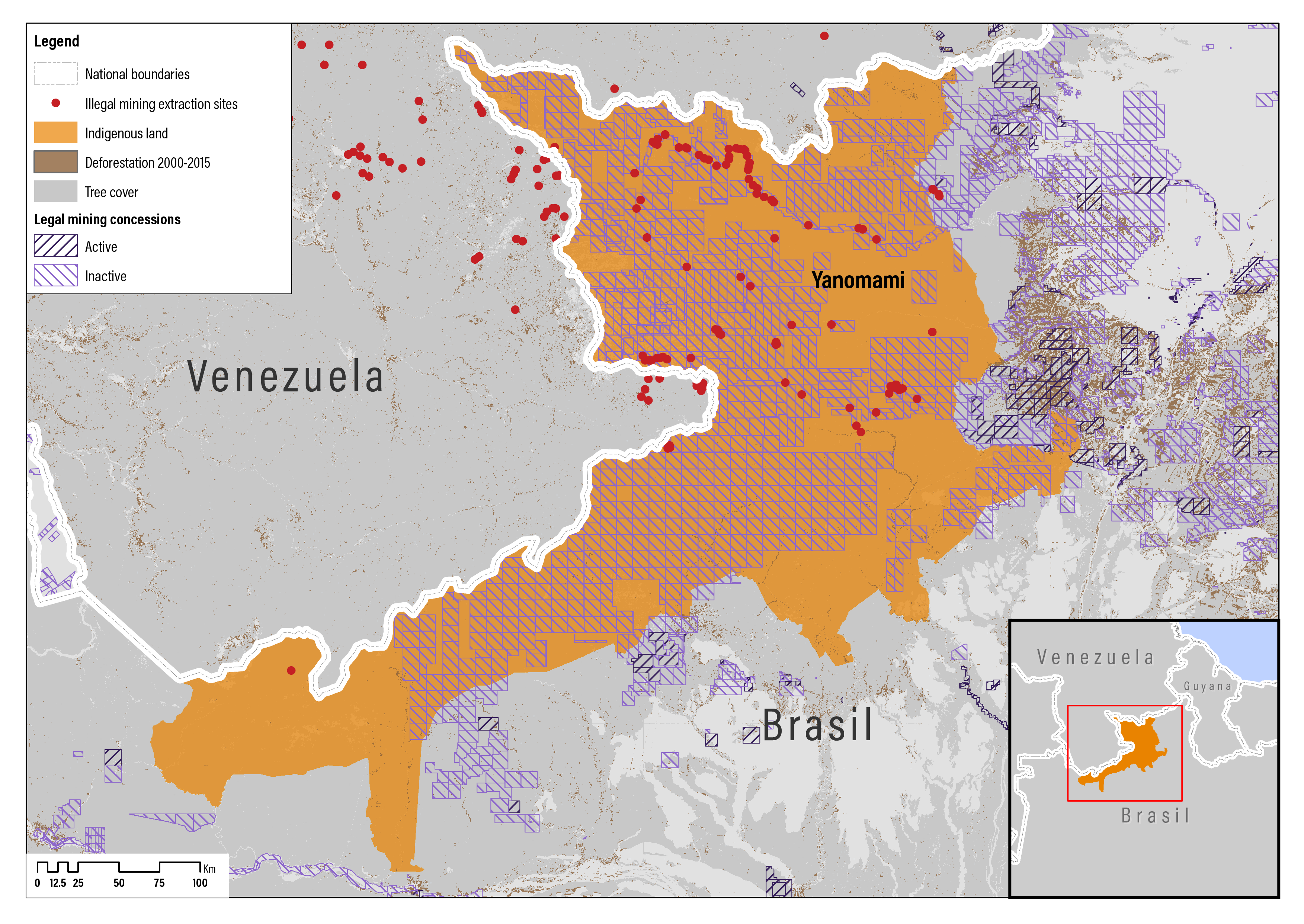
  53. 53. In Venezuela, the Yanomami live in the 8.2 million-hectare Alto Orinoco–Casiquiare Biosphere Reserve (Survival International 2020). Considering Brazil and Venezuela, the Yanomami territory is about 17.8 million ha (178,000 sq. km) (Esri 2019).
  54. 54. The borders are dangerous flashpoints in a showdown between Venezuela's president, Nicolás Maduro, and Venezuela's self-declared interim president, Juan Guaidó, who is supported by Brazil, Colombia, the United States, and other countries.
  55. 55. Known as Moxateteu. Although most Yanomami are in contact with nonindigenous society, one uncontacted group is known to live in the area being invaded, and authorities are investigating signs of up to six other uncontacted communities living there (Survival International 2020).
  56. 56. The Yanomami Park, one of Brazil’s largest indigenous territories, covers 96,650 sq. km of rainforest in the states of Roraima and Amazonas (Branford 2019b).
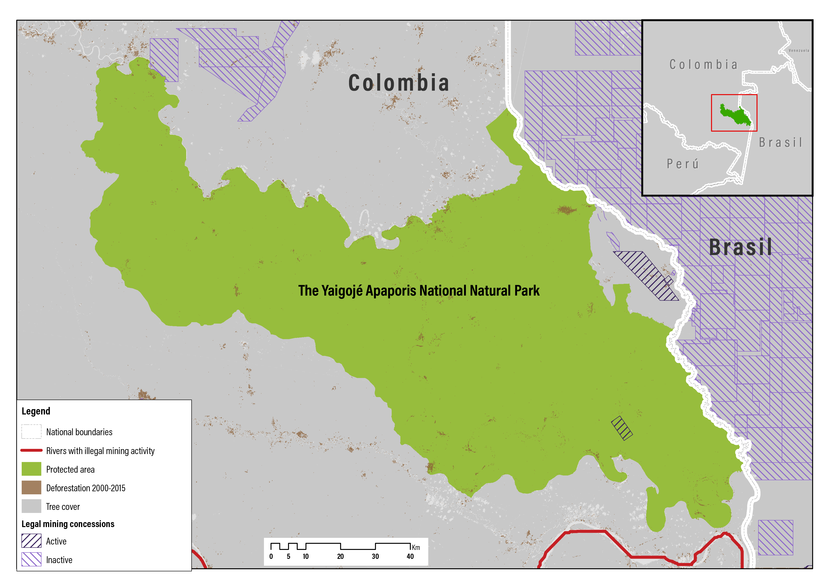
  57. 57. Registered in the Registry of Traditional Indigenous Authorities 2002 (Resolution No. 0135 of October 11, 2002) and 2011 (Resolution No. 009 of February 8, 2011), respectively. Until 2017, the Association of Indigenous Captains of Yaigojé Apaporis Vaupés was known as the Association of Indigenous Communities of Taraira Vaupés (Acitava). The association was created by the captains of some communities in the Department of Vaupés who left Aciya because they did not agree with the creation of the Yaigojé Apaporis National Natural Park. The change of name in 2017 was motivated by the objective of working together with Aciya for the territorial defense of their land.
  58. 58. Indigenous reserves are the collective property of indigenous communities constituted in favor of them (Articles 63 and 329, Constitution of Colombia). They are inalienable, imprescriptible, and unattachable. Indigenous reserves are a legal and socio-political institution of a special nature, made up of one or more indigenous communities. With a collective property title that provides private property guarantees, these communities possess their territory and through an autonomous organization protected by indigenous jurisdiction and its own regulatory system, they are able to govern and manage their lands and internal life (Article 21, Regulation on Titling of Indigenous Peoples’ Lands, 1995).
  59. 59. Cooperation Agreement No. 3.
  60. 60. The consultation process was approved by the appropriate authorities on June 30, 2009.
  61. 61. According to the information provided by the competent authority, Department of Vaupés: Bocas de Taraira, Vista Hermosa, Bocas Uga, Curipira, Santa Clara, Agua Blanca, and Jotabeyá. Department of Amazonas: Puerto Cedro, Centro Providencia, Bellavista, Bocas de Pira, Paromena, Villa Rica, Sabana, La Playa, Unión Jirijirimo, and Cordillera. Campo Alegre y Ñumi (Vaupés) also needed to be considered although it was not in the ethnic group register but belonged to the affected area (Decision Nº T-384A/14, 2014).
  62. 62. The ANM replaced the Instituto Nacional de Investigaciones Geológico-Mineras (INGEOMINAS) in 2011.
  63. 63. There were no mining concessions in the Yaigojé Apaporis Reserve when the request was made.
  64. 64. Mining concession contract IGH–15001X registered in December 13, 2012, in the National Mining Registry.
  65. 65. In response, Cosigo Resources sued the government alleging breach of contract. Until 2016, the condition of the concession was on the exploratory stage.
  66. 66. Decision Nº T–384A/14, 2014. In this case, Benigno Perilla, representing ACITAVA, sued the competent authorities for creating the Yaigojé Apaporis National Natural Park. He alleged the lack of prior information and consultation when the decision was made, and that the establishment of the park would affect the autonomy of its peoples. The Constitutional Court concluded that the consultation processes requirements were met and, thus, no rights were violated.
  67. 67. It is alleged that Cosigo offered bribes to the Taraira communities to oppose the creation of the park (UNDP 2016) and when the company failed to pay, the Taraira communities joined with the other communities to support the park. Cosigo subsequently argued that the indigenous people only have rights over the land, not the subsoil, which is state property. As such, they only need government approval to mine the subsoil for gold, not the support of the indigenous communities (UNDP 2016).
  68. 68. The company requested the extension of the amount of extracted mineral, which was approved by the authority. Thus, according to the expansion of the Environmental Impact Study of the project, the daily volume of treated material was doubled from 30,000 to 60,000 tons.
  69. 69. Since 2013, 47 mining easements have been applied, affecting 14 Cascomi territories (PLAN V 2018).
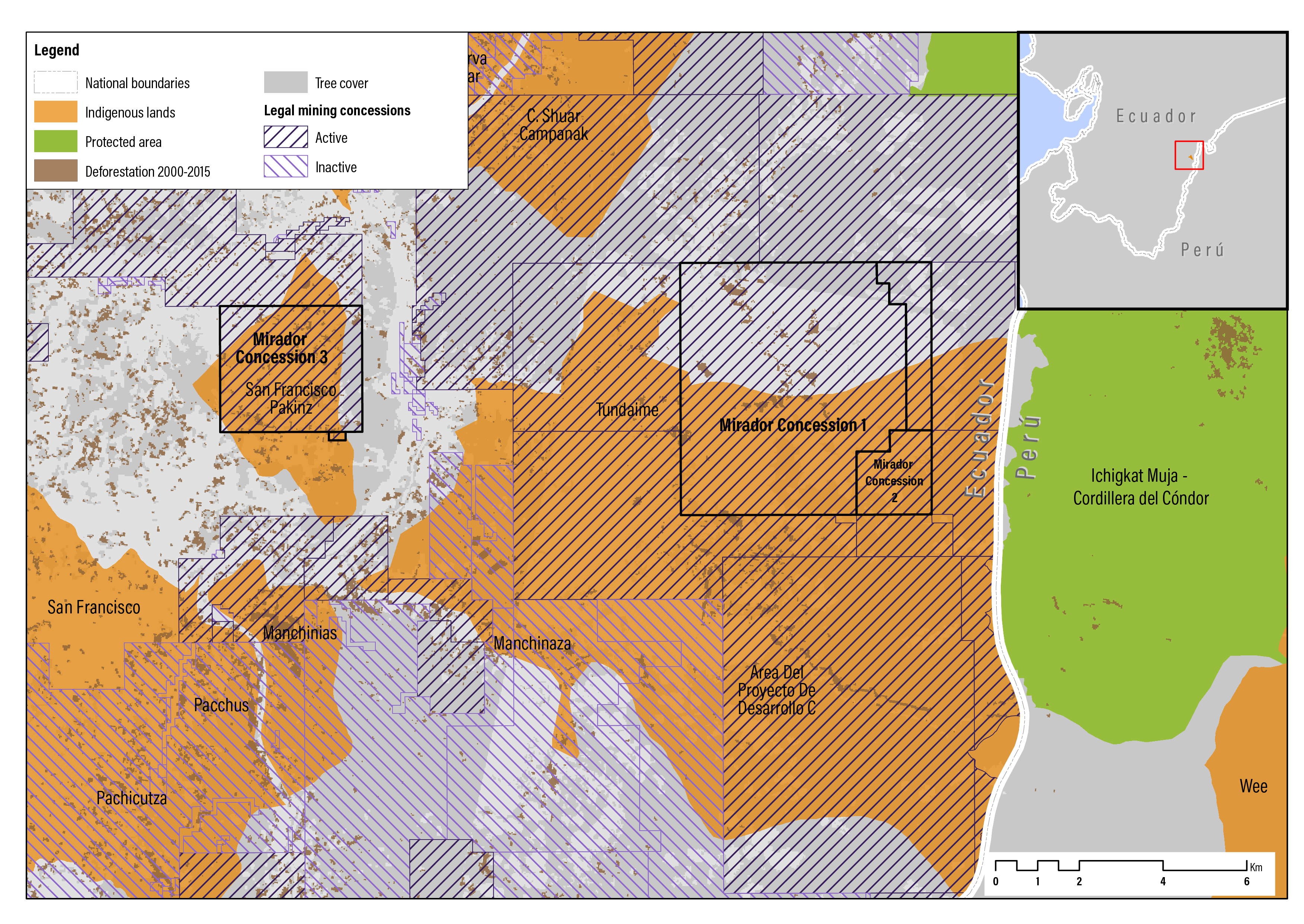
  70. 70. In May 2014, the church and community school of San Marcos, Tundayme parish, El Pangui canton, Morona–Santiago province were destroyed.
  71. 71. The expert indicated that in the territory of CASCOMI there was a Shuar indigenous population—considered an ethnic group that is subject to the collective rights in accordance with the constitution of Ecuador—and a mixed-race population with a collective identification, recognized as farmers, who have acquired cultural practices of the place (INREDH 2019).
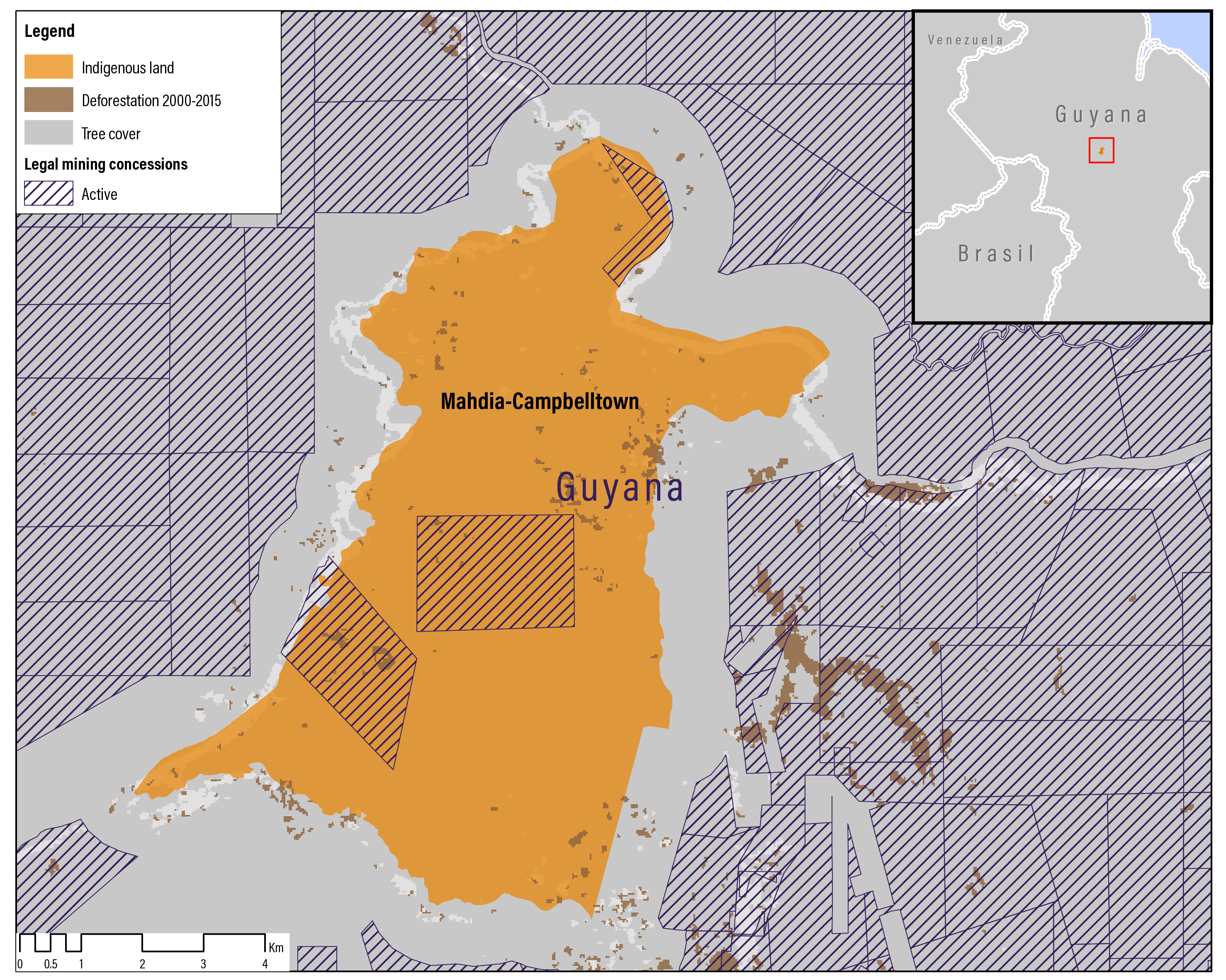
  72. 72. The concession in the north is to METEL and is dated 1998; the center concession is to Asiel Marcus and dated 2004, and the concession in the southwest portion of the indigenous land is to Frank Taylor and dated 2003.
  73. 73. Aside from creating avenues for low-level employment, gold mining is contributing very little, developmentally, to rural Guyanese communities.
  74. 74. In September 2018, Campbelltown welcomed the partners implementing the El Dorado—Responsible Mining for Guyana Initiative designed to eliminate mercury use from small-scale artisanal gold mining. The initiative encompasses a Global Environment Facility (GEF) project and a Norwegian Agency for Development Cooperation-funded mining project with the objective of tackling and reducing the use of mercury in gold mining, as well as the impact of mining activities on forests (GEF 2017).
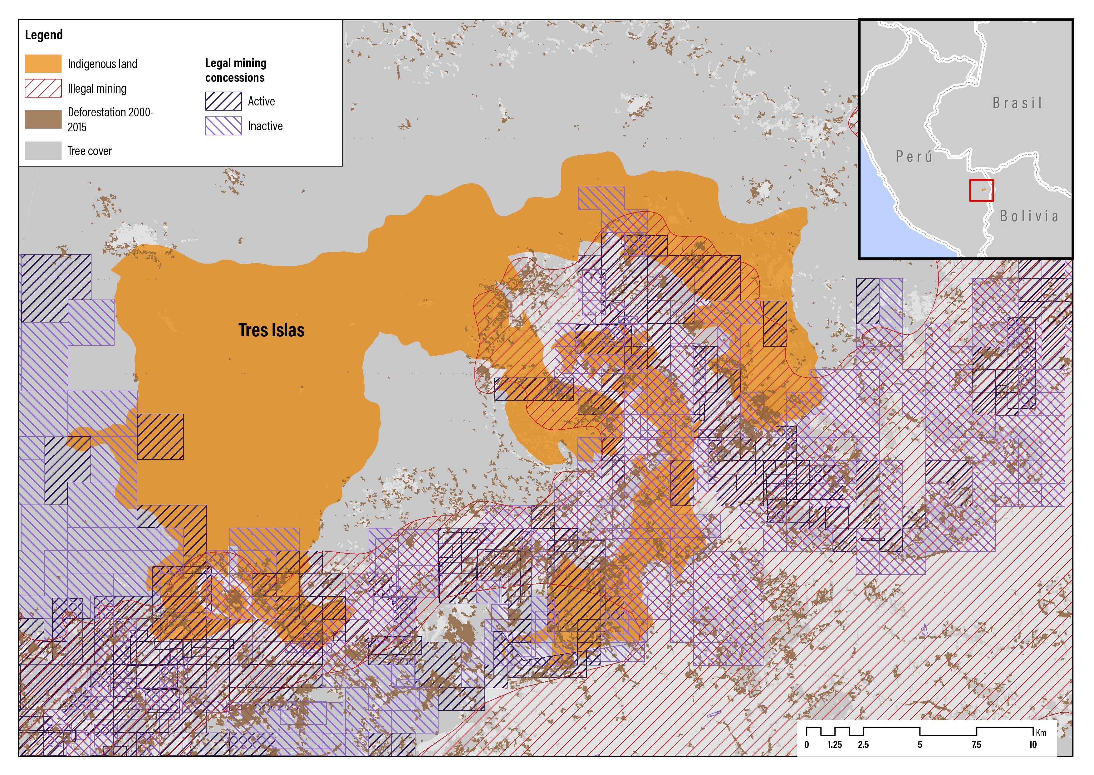
  75. 75. Declarations of the former president of the Tres Islas community on March 2017 (Movimiento Regional por la Tierra 2019).
  76. 76. Of which, 18,402 ha and 7 sq. m constituted lands suitable for cultivation and livestock, and 9,173 ha and 10 sq. m for forestry purposes by the community.
  77. 77. To raise further awareness about the issues, the community members also participated in marches in Lima, Peru’s capital, and spoke about their concerns at public meetings.
  78. 78. In some cases, nonindigenous communities have even fewer rights over their land than indigenous people. Other communal tenure regimes, however, offer similarly strong land ownership rights for nonindigenous identifying communities in Bolivia (quilombolas), Colombia (Afro-Colombian communities), and Peru (Tierras de Comunidades Campesinas con Aptitud Forestal).
  79. 79. Land and high-value natural resources are often governed by different sets of national laws and administered by different government agencies.
  80. 80. A value chain is a set of activities that a firm operating in a specific industry performs in order to deliver a valuable product (i.e., good and/or service) for the market.
  81. 81. The law or rules of evidence clarify how strong evidence must be to meet the legal burden of proof in a given situation, ranging from reasonable suspicion to preponderance of the evidence, clear and convincing evidence, or beyond a reasonable doubt.
  82. 82. High-value minerals are commonly national or public goods with national governments receiving most of the revenue from mining companies in the form of taxes, fees, and royalties. This public revenue is used for national development with the affected local governments and communities rarely receive their fair share.
  83. 83. For example, the Newmont Ahafo Mine Development Foundation Agreement in Ghana, West Africa, contains multiple types of financial benefit sharing. The agreement requires the company to pay to a community foundation $1 for every ounce of gold from the mine sold, as well as 1 percent of the company’s net pre-tax income, and of any gains made in selling assets that total $100,000 or more (Loutit et al. 2016).
Start reading