report

UNDERMINING RIGHTS

Indigenous Lands and Mining in the Amazon

Patricia Quijano Vallejos Peter Veit Pedro Tipula Katie Reytar
Partners:
Download PDF

Data Collection and Analysis Methods

The research examined mining on indigenous lands in the Amazon with a focus on Bolivia, Brazil, Colombia, Ecuador, Guyana, and Peru. Data and information were collected by conducting literature reviews; reviewing the relevant national laws; preparing six case studies of indigenous experiences; and conducting a geospatial analysis to examine forest cover change on indigenous lands affected by mining across the Amazon and the six case study sites. This report presents the data, analysis, and principal findings of the research.

Research Countries

The research for this report focused on collecting data and information on six Amazonian countries—Bolivia, Brazil, Colombia, Ecuador, Guyana, and Peru. The geospatial analysis focused on the biogeographic boundary of the Amazon, or Amazonian biome. Data on both legal and illegal mining were available for Bolivia, Brazil, Colombia, Ecuador, Peru, and Venezuela (see below).

Bolivia, Brazil, Colombia, Ecuador, Guyana, and Peru were selected for multiple reasons. Collectively, they hold 90 percent of the Amazon basin and 93.4 percent of the Amazonian population, including most of the indigenous peoples in the region (Table 1.1 and Box 3.1). Brazil has the second-largest forest in the world (behind Russia), while Colombia, Peru, and Bolivia are among the world’s top 10 countries with the most forests. More than 90 percent of Guyana is forested, among the highest percentages in the world.

box 3.1 | Definitions

Indigenous Peoples: People with distinct social, cultural, or economic characteristics, practicing in part or in full their own customs or traditions. The term includes those who are descended from people inhabiting a country or region at the time of conquest, colonization, or the establishment of modern boundaries. Whether a group of persons is considered to be indigenous is based on self-identification (ILO Convention 169). The rights of indigenous peoples receive heightened protection under international law. Governments have a responsibility to recognize the unique relation that indigenous peoples have to their traditional or ancestral lands.

Indigenous Land or Territories: Collectively held and governed lands (and natural resources) of indigenous peoples. As with other community land, some indigenous land may, with group consent, be allocated for use by individuals and families. Other indigenous land is managed as common property.

Source: Notess et al. 2018.

Mining occurs on indigenous lands in all six countries, and government reforms with impli-cations for mining on indigenous lands are under-way in all research countries. Further, information on the law and practice of mining on indigenous lands, including spatial data on indigenous lands, legal and illegal mining, and forest cover, is available for the research countries.24

At the same time, important differences in the research countries allow for comparative analysis. The legal framework of mining on indigenous lands, rights of indigenous peoples over their lands and the minerals contained within them, as well as the authorities and obligations of miners operating on indigenous lands differ in significant ways in the research countries. Implementation and law enforcement also vary across the six countries.

The research focused on minerals and mining. Geologists define a mineral as a substance that is naturally occurring, inorganic, and solid with a definite chemical composition and an ordered internal structure (UA 2005). For the purpose of this research, minerals include rocks, gravel, and sand, but not oil or natural gas. Hydrocarbons were excluded from this research because they are regulated by a set of distinct laws, not the mineral or mining laws, and current geospatial data on oil and natural gas concessions are not readily available. Moreover, while many indig-enous peoples engage in mining, the extraction of hydrocarbons is more complex and difficult for them to engage in directly.25

Research Methods

Data were collected and analyzed from literature reviews, geospatial analysis, legal reviews, and case studies.

Literature reviews: The research involved both a broad review of the literature on mining on indigenous and community lands globally and more focused reviews on the six research countries. The reviews examined the academic and gray literature in Spanish, English, and Portuguese (e.g., government reports, NGO literature, and international organization documents) and were designed to better understand the state of knowledge on the issue of mining on indigenous lands. News articles in popular media outlets were also reviewed to understand the current state of affairs in the six research countries, including any ongoing reforms and other developments with implications for mining on indigenous lands through April 2020.

There is a large and growing body of literature on mining on indigenous and community lands globally and in the Amazon specifically. The literature review for this research was not exhaustive. Rather, the review focused on the most salient and the most recent (from the last 10 years) literature on mining on indigenous lands, as well as on the interpretation of relevant laws and regulations by local experts and international scholars. Online and library searches were conducted through Google and Google Scholar using search words, including mining, indigenous peoples/lands, Amazon, and other key words. Sources were also identified from the reference sections of relevant articles and other documents. In addition to online and library searches, local and country experts helped identify and access additional literature for the reviews (see Acknowledgments).

Geospatial analysis: The analysis of the extent and impact of mining on indigenous lands and forest cover in the Amazon was conducted using spatial data and geographic information system (GIS) analytical tools. The Amazon Geo-Referenced Socio-Environmental Information Network (Rede Amazônica de Informação Socioambiental Georreferenciada, RAISG)26 supplied most of the data and conducted much of the analysis. The geographic extent of the analysis was the biogeographic boundary of the Amazon (as defined by RAISG), excluding French Guiana because of the absence of critical data.27 The Amazon-wide data were analyzed by country for the purpose of comparing results across different national contexts. The GIS analysis also included assessing mining and forest cover change on the indigenous lands in the six case studies.

To examine the relationship between indigenous lands, mining, and forest cover, a spatial analysis was performed where data sets were overlaid, and the area of overlap quantified and summarized by country and by the indigenous lands of the six case studies. The data on indigenous lands were sourced from RAISG (RAISG does not collect spatial data on Afro-descendant or other types of communities that hold land in a collective manner). Because each country uses different terminology to describe their indigenous lands, RAISG organizes the data on indigenous lands into categories based on their legal status (Appendix A). Additional information on each data set used in the analysis, including source and relevant notes, is provided in Appendix B. (Note: All data sets were not available for every Amazonian country.)

The data on legal, large-scale mining concessions varied by source and were not consistent in their level of detail in terms of identifying the status of mining activities (RAISG holds concession data for all Amazonian countries except French Guiana). For example, the mining data for Brazil differentiated between concessions that were “in exploration” versus those that were “in exploitation,” while Peru and other countries grouped these classifications together as “in exploration or exploitation.” There is no data on whether mining operations in concessions that are in exploration or exploitation cover the whole of the concession area or are focused on certain sections of the concession.

To compensate for the variable information across countries and data sets, the classes were consolidated into categories of “active” or “inactive” (Table 3.1). Three countries—Bolivia, Ecuador, and Guyana—identified concessions as having “no information” on their status.28

The concession data for Brazil—dated January 2018—were sourced from the National Department of Mineral Production (Departamento Nacional de Produção Mineral, DNPM), the Brazilian federal agency which oversaw mining regulation and inspection under the Ministry of Mines and Energy. RAISG compiled and standardized the DNPM mining concession data for Brazil (and the other Amazonian countries). The official government mining data for Brazil show that 270 active mining concessions overlap with indigenous lands in the Amazon (out of a total of 35,653 mining concessions, including 11,088 active concessions and 24,565 inactive concessions). Of these, 237 concessions are designated as being in exploration and 33 are designated as in exploitation. It was not possible to assess whether the 270 active mining concessions that overlap with indigenous lands in Brazil are operating. For the purpose of the GIS analysis, these concessions are considered active, as was designated in the data sourced from DNPM.

RAISG does not collect or hold data on legal ASM in the Amazon so the GIS analysis for this report does not examine the overlap of ASM on indigenous lands or its link with deforestation.

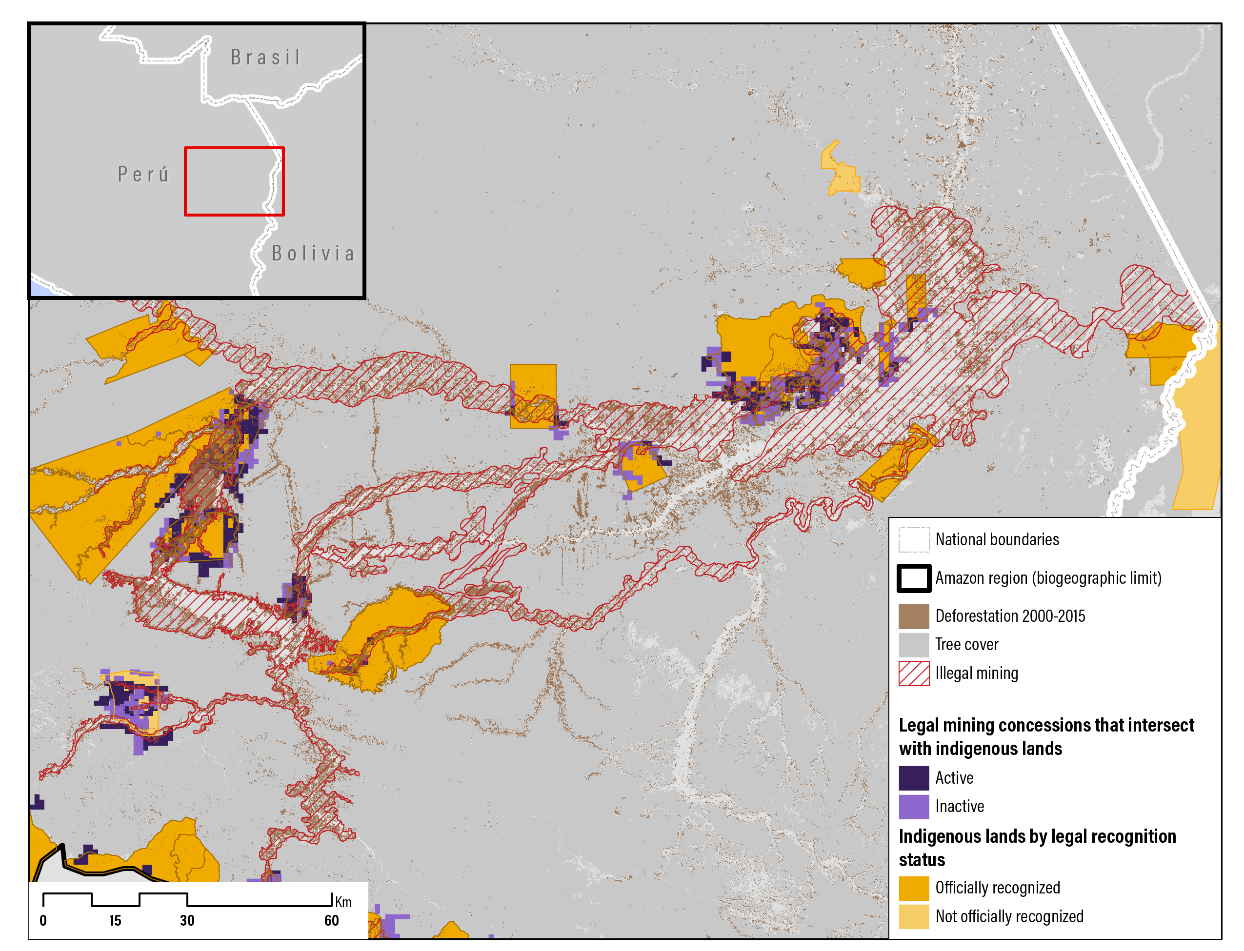
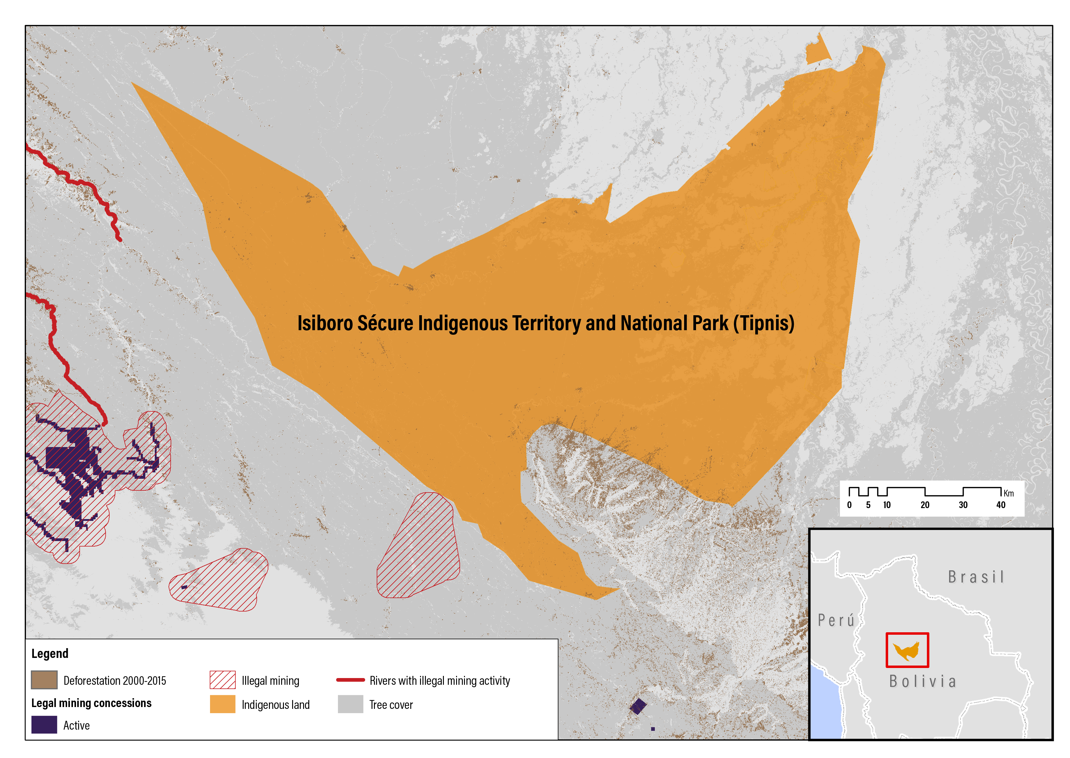
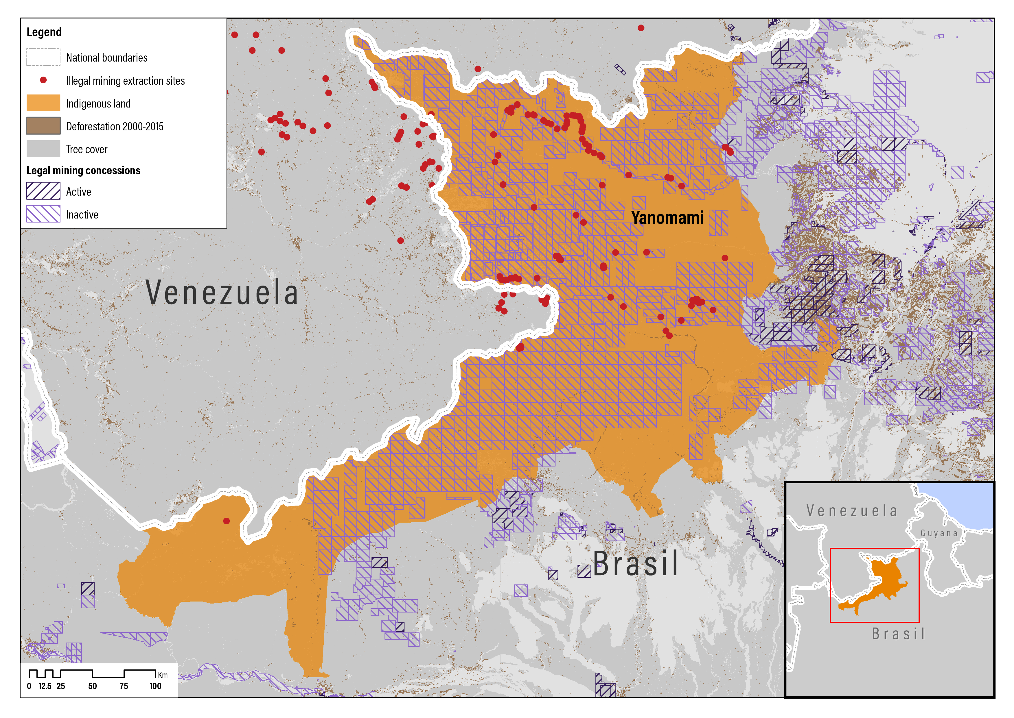
RAISG collects and holds data on illegal mining in six Amazonian countries—Bolivia, Brazil, Colombia, Ecuador, Peru, and Venezuela—and these data were included in the GIS analysis (RAISG does not collect data on illegal mining in Guyana, French Guiana, or Suriname). For this research, a larger data set was used than in RAISG’s 2018 survey (RAISG 2018a), including data for Venezuela that were updated in 2019. The methods for collecting data on illegal mining activities varied by country, including from reports by indigenous peoples, news media, and satellite image analysis. Three types of illegal mining areas were defined for the analysis: extraction areas (polygons) were defined by assessing satellite imagery and using knowledge of regions where illegal mining is known to occur (based on news reports and experts in the field); extraction sites (points) of illegal mining activities were identified using news reports or other local information; and rivers affected by mining (lines and polygons) were identified based on local reports (RAISG 2018a).

The analysis of illegal mining for this report used the biogeographic region of the Amazon, excluding French Guiana and Suriname. The RAISG survey in 2018 considered a larger Amazon region. Further, the 2018 survey consolidated the various indigenous lands that were not contiguous into one territory (many indigenous territories consist of several separate indigenous lands), while this analysis counted every indigenous land (polygon) separately.

To examine the links between mining (legal concessions and illegal mining) on indigenous lands and forest cover in the Amazon, a spatial analysis was conducted that compares areas of known mining activities with indigenous land and forest cover change. Deforestation rates on indigenous lands with active concessions were calculated for the time period from 2000 to 2015 and compared with the deforestation rates on indigenous lands without mining (i.e., the analysis did not calculate deforestation rates on indigenous lands with concessions that are labeled as inactive or concessions that had no information on whether they were active or inactive—see above).

In order to estimate forest cover change within illegal mining areas, the point data were buffered to a distance of 10 km and line (river) data were buffered to a distance of 5 km. These distances represent the average extent of impacts and are based on the GIS analyst’s experience and judgment. The forest cover data are sourced from RAISG and cover three time periods: 2000–05, 2005–10, and 2010–15 (RAISG 2015). To estimate the percentage of deforestation that occurred over these time periods, a baseline forest cover data representing the year 2000 was used as the point of departure (also sourced from RAISG).

Table 3.1 | Comparison of the Mining Status, as Defined in the Data Sets, with How the Data Were Consolidated and Merged

Mining Status, as Defined in the Data Sets

Consolidated Status

In exploration

Active

In exploration or in exploitation

Active

In exploitation

Active

Potential/Open for bidding

Inactive

Under tender/under request

Inactive

No information

Unknown


Source: D.H. Bebbington et al. 2018a.

The GIS analysis evaluates the association of mining activities and forest cover change; it is not possible to infer causation from this analysis. In other words, one cannot assume that forest cover loss, which has occurred within an area identified as a site of legal or illegal mining, was caused by mining or another action. This analysis seeks to evaluate whether indigenous lands that have mining concessions or illegal mining activities within their boundaries tend to be more vulnerable to forest loss in general, which may or may not be related to mining operations. These findings are thus a good starting point for further research that can allow more causal inference.

Legal reviews: The legal reviews focused on Bolivia, Brazil, Colombia, Ecuador, Guyana, and Peru. Based on the literature reviews, four critical issues were identified as central to understanding the dynamics of mining on indigenous lands:

  • Ownership of mineral resources: Who owns minerals in the research countries? What rights do indigenous peoples have over the minerals on and below their lands? What authorities do miners have to enter and use indigenous lands to exercise and realize their mineral rights?
  • Allocation of mineral rights: Can indigenous peoples mine their lands for customary and commercial purposes? Do indigenous peoples have the right of first refusal to commercially mine their lands? What rights do indigenous peoples have when the government allocates rights to minerals on and below the surface of indigenous lands?
  • Consultation and consent: Do indigenous peoples have the right of free, prior, and informed consultation or consent? Must the government consult or have the consent of indigenous peoples before granting rights to minerals on indigenous lands to third parties? Must miners consult or have the consent of indigenous peoples before conducting mining operations on indigenous lands?
  • Protection of indigenous lands: Is mining prohibited on indigenous or other lands? Does the government have the responsibility to monitor and oversee mining operations on indigenous lands? Are miners responsible for damage to indigenous lands caused by their operations? Must miners restore the land after their operations?

To help ensure consistency in data collection across the six research countries, a set of indicators or questions was developed for each issue and consistently applied in the legal reviews for each research country (Appendix C).

The legal reviews focused on the laws that govern indigenous lands and regulate mining on indigenous lands in the research countries. In some cases, the laws governing indigenous lands also govern other types of collectively held land tenure systems. Where there are separate laws for different types of collectively held lands such as indigenous lands, Afro-descendant lands, and other nonindigenous community lands, these laws were also reviewed but principally to compare them with the laws governing indigenous lands (i.e., the legal reviews did not include a complete analysis of the laws and regulations of mining on nonindigenous lands).

The most relevant laws for review for each research country were identified from govern-ment websites and country profiles at FAOLEX database (Food and Agriculture Organization, FAO), and from interviews with country experts (see Acknowledgments). Relevant national (or federal) laws enacted before April 2020, including constitutions, statutes, regulations, decrees, technical directives, and court rulings of relevant cases, were reviewed to the extent they were available (Appendix D). Two international instruments and three pending bills in Brazil were also reviewed. The legal reviews did not examine subnational laws and regulations, government policies, or political statements that are not legally binding.

In most cases, the laws were read and reviewed in their original, official language, although for Brazil’s laws in Portuguese, good-quality (often official) translations were used. Secondary sources (e.g., development and academic literature) and legal commentaries were consulted if the law or court ruling was ambiguous or not available. Government and independent legal experts from the research countries were also consulted to ensure the interpretation of the law is consistent with local understanding and how it is applied in the country by governments, advocates, scholars, and other stakeholders (see Acknowledgments). It was not possible to get the viewpoints of the full set of stakeholders (e.g., mining company officials, ASM miners, and nonindigenous communities). Future research could reach out to the full range of stakeholders.

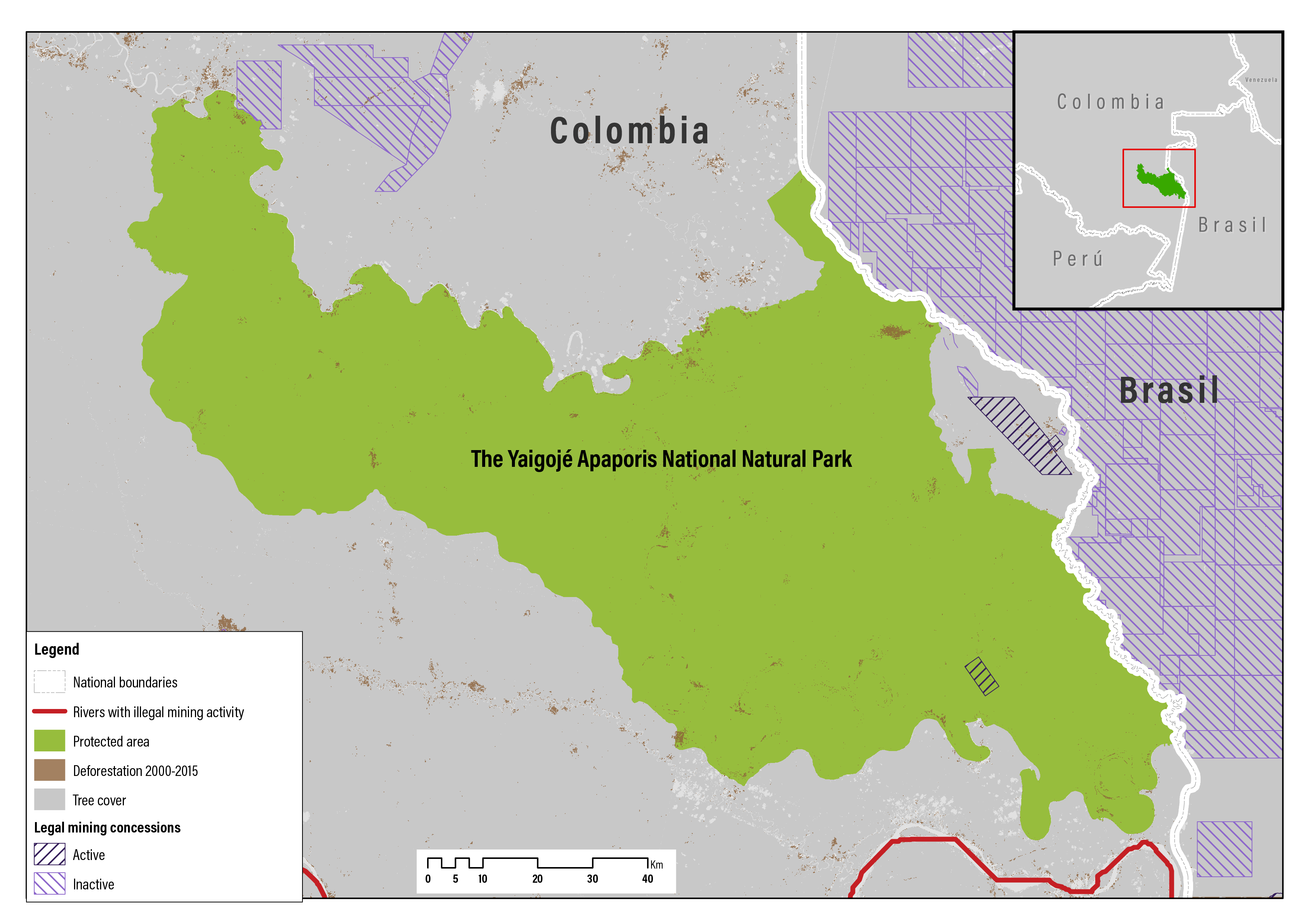
Case studies: To better understand the implementation and enforcement of laws, and the practice of mining on indigenous lands, case studies were developed of six community experiences of mining—or the threat of mining—on indigenous lands. One case study was developed from each research country. A list of potential case studies was developed for each research country from the literature reviews, Internet searches (especially of national newspapers and other local media), and from interviews with country experts (see Acknowledgments). The case studies were carefully selected to document a variety of strategies and approaches used by indigenous peoples—some effective, some not—to protect their lands from mining or to mitigate the negative social and environmental impacts of mining on their lands.

Information for the case studies was gathered from two sources. Desk research was conducted to collect and review the academic and gray literature as well as news articles in the local and international media on the specific community experience. As with the literature reviews, online and library searches were conducted using Google and Google Scholar using search words, including mining, indigenous people/lands, the community name, and other key words. Sources were also identified from the reference sections of relevant articles and other documents. In addition, one or more government and/or independent experts with knowledge of the affected indigenous peoples was interviewed in the research countries to complement the information gathered from the literature (see Acknowledgments).

To ensure consistency in the case studies across countries and to assess law enforcement, each case study addressed the same four issues—ownership of mineral resources, allocation of mineral rights, consultation and consent, and protection of indigenous lands—and associated indicators/questions for the legal reviews (although gaps in the literature and understanding by the interviewed experts prevented addressing every indicator/question for each case study).

Start reading